Speaker Information: 7th Kenji Ishihara Colloquium Series on Earthquake Engineering
Fault Displacement
Speakers and Abstracts
Dr. Norman Abrahamson
Adjunct Professor, University of California, Berkeley and University of California, Davis
Selection of Design Fault Displacements for Moderate-Activity Faults
Abstract: Design ground-motion values are commonly based on probabilistic seismic hazard analysis (PSHA), whereas design fault displacement values have often been estimated using deterministic seismic hazard analysis. To treat ground motion and fault displacement consistently, there has been a growing demand for probabilistic fault-displacement hazard analysis (PFDHA) for selecting design fault displacements; however, choosing the fault displacement from a PFDHA based on the same return period as used for the ground motion may not lead to consistent levels of risk for moderate-activity faults (slip rate between 0.2 and 2 mm/yr) if the hazard curve has a flat slope at the selected return period. In this case, the epistemic uncertainty in the slip rate on the fault will lead to a very large range for the fault displacement at the selected return period.
For moderate-activity rates, alternative approaches for selecting a design fault displacement are described: risk-targeted displacement approach, high-fractile hazard approach, and median displacement given surface rupture at the site approach. If it is not practical to design for the fault displacement, an alternative approach is described in which an emergency action plan is developed to respond to the expected damage from fault displacement rather than design the structure to withstand the fault displacement.
Bio: Dr. Abrahamson is an internationally-known expert in seismic hazard and risk analyses, with a focus on the practical application of engineering seismology to the development of deterministic and probabilistic seismic criteria for engineering design and evaluations of seismic risk. He has been involved in developing or reviewing design ground motions for hundreds of critical infrastructure projects around the world. He is an adjunct professor at UC Berkeley, and UC Davis, where he teaches a graduate course on seismic hazard analyses, development of design time histories, and seismic risk. His current research is focuses on non-ergodic ground-motion and fault rupture models, treatment of aleatory variability and epistemic uncertainty in site response, numerically efficient methods for evaluating seismic hazard for complex source and ground-motions, and decision making using hazard or risk estimates with large epistemic uncertainties.
Frank Bannon, P.E.
Senior Engineer, Reid Middleton, Inc.
Evaluation of Existing Buildings Located on Active Fault Lines
Abstract: Current building regulations generally prevent new construction on known active fault lines due to fault rupture hazards. However, there is limited guidance on how to evaluate existing buildings that were constructed on fault lines before these regulations were put in place. ASCE 41 provides minimal guidance on analyzing and mitigating fault rupture hazards. This presentation is intended to initiate discussion about how engineering professionals can evaluate existing structures on fault lines that are subject to fault rupture. Included in this presentation is a case study of a 10-story reinforced concrete shear wall building with deep pile foundations where a recent geological investigation revealed that several fault lines were located directly underneath the building, with the potential to cause fault rupture at the surface level.
Bio: With more than 10 years of structural design experience, Frank works as a senior engineer and project manager for Reid Middleton, Inc. in San Diego, California. His project experience includes various structure types, including concrete tilt-up, concrete tanks, steel frames, steel pedestrian bridges, and retaining walls. He also has experience conducting seismic evaluations and provided associated seismic retrofit concept design. Frank is a licensed Civil Engineer in California. He holds a Bachelor of Science degree in Civil Engineering from the University of Delaware.
Craig D. Comartin
President, CDComartin, Inc.
Structural effects of large seismically induced permanent ground displacements
Unfortunately, Dr. Comartin is no longer able to present at this year’s colloquium.
Abstract: This presentation comprises three parts. First observations of building and foundation performance from past earthquakes are reviewed. From these the design implications for new and existing construction are presented. Finally, three case studies are presented as examples of applications of soil structure interaction for large permanent displacements of structures. The first is the construction of the state of Alaska Supreme Court building constructed upon the existing L Street Slide in Anchorage, AK. Two more examples are discussed both of which are on the University of California, Berkeley campus, one being the retrofit of California Memorial Stadium and the other being the retrofit of Bowles Hall immediately north of the Stadium.
Bio: Craig D. Comartin is a structural and geotechnical engineer with over 50 years of experience. His work includes both research and practical applications. He has developed procedures for including the effects of soil structure interaction there are now considered the standard in the industry. This includes the subject of this presentation on large permanent displacements at surface expressions of fault movement. He is former president of the Earthquake Engineering Research Institute. In this capacity he was instrumental in establishing local chapters of EERI including in San Diego. He has filed reports on numerous earthquakes from around the world. He is an honorary member of EERI and the Northern California Structural Engineers Association. He was awarded the Alfred Alquist Medal for his work raising awareness of non-ductile concrete buildings and the development of procedures for construction of unreinforced masonry buildings in economically challenged areas of the world.
Jim Gingery, Ph.D., P.E., G.E.
Chief Engineer, Keller North America
Deep Soil Mixing Design and Construction for Surface Fault Rupture Mitigation
Abstract: Deep soil mixing ground improvement was used to mitigate surface fault rupture and liquefaction hazards for a pump station with wet wells up to 36 feet deep. Paleoseismic field investigations were performed to characterize the site, then deterministic and probabilistic fault rupture displacement estimates were made and used to develop design scenarios. The fault rupture mitigation design consisted of a solid block of DSM encompassing and protecting the pump station and its wet wells. Three-dimensional soil-structure interaction numerical modeling of the fault rupture scenarios was performed as part of the design. The analyses showed the fault rupture displacements could be diverted by the DSM and that satisfactory structure performance could be achieved. The presentation concludes with an overview of the DSM construction, and quality control and assurance.
Bio: Dr. Gingery is a Chief Engineer at Keller leading a team providing ground improvement and geostructural engineering for design-build projects across the Western U.S. and beyond. Dr. Gingery holds an M.S. in geotechnical engineering from UC Berkeley and a Ph.D. in geotechnical earthquake engineering from UC San Diego. He has more than 27 years of experience in research, consulting, design, and construction, and is a license professional engineer in multiple states. In 2015, he was awarded the Shamsher Prakash Prize for Excellence in the Practice of Geotechnical Engineering.
Zeynep Gulerce, Ph.D.
Nuclear Safety Officer, International Atomic Energy Agency
The IAEA Probabilistic Fault Displacement Hazard Assessment Exercise
Abstract: IAEA Safety Standards Series No. SSR-1, Site Evaluation for Nuclear Installations, identifies fault capability as one of the potential challenges to the safety of nuclear installations. In the site selection and characterization of new nuclear installation sites, sufficient geological, geophysical, geotechnical and seismological data are obtained to demonstrate the existence of a capable fault at or near the site. Although the capable fault issues are expected to be addressed at these stages, subsequent studies may reveal that there is potentially a capable fault in the site vicinity of existing nuclear installations. For this case, IAEA Safety Standards Series No. SSG-9 (Rev. 1), Seismic Hazards in Site Evaluation for Nuclear Installations, recommends the assessment of the potential for fault displacement using probabilistic methods. In the past decade, challenges associated with the application of probabilistic fault displacement hazard analysis (PFDHA) in different tectonic settings have been recognized, and new and improved empirical fault displacement models have been published. To follow up on the recent advances in this field and for a better understanding of the PFDHA results for scenarios that may be related to nuclear installations, the IAEA designed a PFDHA exercise. This exercise aims to support the implementation of the recommendations given in SSG-9 (Rev. 1) by comparing the hazard results and interpreting the pieces of the PFDHA that contributes to the observed differences.
Bio: Zeynep Gulerce is a Nuclear Safety Officer and responsible technical officer for the IAEA Benchmarking Exercise on Probabilistic Fault Displacement Hazard Assessment. In IAEA, Ms. Gulerce is working on the tasks related to hazards from external events that may impact the safety of nuclear installations. Before taking her position in IAEA, she had worked as a full-time faculty member in Middle East Technical University and part-time consultant for the Turkish Nuclear Regulatory (NDK). Ms. Gulerce’s research efforts were focused on the state-of-the-art in seismic hazard assessment, characterization of design ground motions, and geotechnical earthquake engineering, which led to the publication of numerous scientific papers, book chapters, and technical reports. She has more than 20 years of experience in the analysis of earthquake hazards/risks, as a civil engineer working in a seismically-active country. She had provided technical consultancy to several large-scaled construction companies of Turkey, specifically on the analysis of geo-hazards for site characterization, inspection, review and assessment of hazards for defining the site parameters, and licensing procedures.
Monte Marshall, Ph.D.
Professor Emeritus, San Diego State University
The Resolution of Two Important Questions About the Nature of the San Andreas Fault
Abstract: The San Andreas fault is one of the longest and probably the most famous and well-studied strike-slip faults in the world, but geologists knew surprisingly little about it before the devastating 1906 San Francisco earthquake. In this talk, I will discuss two advances in our current understanding of this important fault: how the modern discovery of plate tectonics resolved a decades-long controversy about the very large total offset on the fault, and why a 170 km length of the fault in central California generates only minor earthquakes.
Geologists at UC Berkeley had just finished mapping the San Andreas fault from northern California south to the Imperial Valley only months before the earthquake. But they had no idea of its terrible potential. Immediately after the earthquake, the California governor authorized a state commission of geologists, mostly from UC Berkeley and Stanford, to study the fault and ground conditions responsible for the catastrophic damage and loss of lives. They were amazed when they found that the fault had slip/ground rupture that extended almost 400 kilometers. It was the longest fault rupture that had ever been recorded! They found that the slip between the two sides was usually horizontal, or “strike-slip.” The commission geologists found the rupture extended south of San Francisco 130 km to the small town of San Juan Bautista. They traced it north 250 km to Point Arena, where the fault goes out to sea. The maximum offset was 6 m near Point Reyes, about 50 km north of San Francisco. In the decades following the 1906 San Francisco earthquake, geologists began to find unusual rock types and complicated structures that were cut by the San Andreas fault, lay on both sides of the fault, but the two ‘halves’ were 200 km to 300 km apart! This much total offset on the fault was very controversial, and for good reasons seemed mechanically impossible! For example, when the Earth’s crust on the west side of the San Andreas moved north about three meters at Point Reyes and didn’t move at all 130 km to the south at San Juan Bautista, that length of the crust would be under tension. And the crust on the west side of the San Andreas from Point Reyes north to where the fault ends would be under compression. The physical effects of the tension and compression associated with only a few meters of differential offset spread over thousands of meters would be negligible. But 300 km of total offset on a fault that was believed to end on the north at Cape Mendocino and end 1000 km to the south near the Salton Sea, was (correctly) thought impossible! With only a fraction of 300 km of total offset, at each end there should be mountains on one side of the fault and a gigantic, very deep hole on the other! The controversy about the total amount of offset on the San Andreas raged until 1969, when the new paradigm of plate tectonics was proven. A symbiotic combination of oceanographers, seismologists, and geophysicists discovered that the earth’s outer 100 km was broken into slabs, called “plates”, that move relative to one another. In the late nineteen sixties, the Mid-Atlantic Ridge and East Pacific Rise were proven to be seafloor spreading centers, i.e., places where oceanic plates diverge. The deep sea trenches were also quickly shown to be subduction zones, i.e., places where an oceanic plate dives under another oceanic plate or a continental plate. But, a third kind of plate margin was observed, one where crustal slabs slide past one another along a new kind of fault, called a “transform” fault. And, if the San Andreas fault is a transform fault, there would be no mechanical problem with it having hundreds of kilometers of strike-slip displacement! In 1970, a brilliant grad student at Scripps Institute of Oceanography, Tanya Atwater, used the marine magnetic anomally data off the west coast of North America to show when and how the San Andreas fault was born as a transform plate boundary between the North American and Pacific plates. And, at about the same time, marine magnetic anomalies at the mouth of the Gulf of California enabled oceanographers to both date when Baja California rifted away from mainland Mexico (about 5 Ma), and the rate (about 50 mm/yr) at which Baja and Alta California have been moving north. This rate of 50 mm/yr is the accepted value for the rate at which the Pacific plate is moving northward past the North American plate, i.e., the combined rates of all the strike-slip faults in the San Andreas System. The section of the San Andreas fault that lies between the southern end of the 1906 rupture at San Juan Bautista and the northern end of the great 1857 Ft. Tejon earthquake rupture near Cholame is unusually quiet. Called the “creeping zone”, plate movement in this 170 kilometer-long section consists only of aseismic slip, and many small and occasional moderate (M6) earthquakes. The rocks in this length continuously slide past one another. The two most popular ‘end-member’ explanations for this unusual behavior are that the fault gouge along this length of the San Andreas has an unusually low coefficient of friction, or that unusually high water pressure in the fault zone greatly reduces the normal stress between the slip surfaces. To help understand what makes this section so special, a well was drilled near its southern end in the summers of 2004 to 2007. The well was drilled vertically at first and then deviated to intersect a seismically active zone at a depth of 2.7 km. Cores were taken of the fractured rocks in the fault zone and samples were obtained of the fault gouge. The fault gouge was found to consist of a special clay having a friction coefficient as low as 0.1! At least at this site in the creeping section, a very slippery fault gouge appears to be more influential than pore pressure in preventing the large build-up of shear strain that has proved so disastrous in regions to the north and south.
A geophysics professor from Johns Hopkins, H. F. Reid, made another important, but much less obvious, observation. He noticed that the location of points, as measured by several geodetic surveys made over the thirty years before the earthquake, differed systematically with their location measured shortly after the earthquake. The Earth’s crust out to a distance of about 10 km from the SAF had been gradually bent during the 30 years before 1906, but the crustal bend was gone after the earthquake. He realized that a huge amount of elastic strain energy had been accumulating in this bend during the past thirty years, and probably a lot more since the previous earthquake. So, he proposed that the cause of the earthquake was the release of the energy stored in the bent rocks on both sides of the fault when the rocks suddenly rebounded during the fault slip. “Elastic rebound” is still considered the energy source of most earthquakes.
Bio: “As a fourth-generation San Diegan, I was born in Mercy Hospital in 1939. I attended St. Augustine High School, and then headed east to Philadelphia where I attended Villanova University. I majored in philosophy and minored in astronomy. Upon returning to San Diego, I enrolled at SDSU as an astronomy major. My uncle was a meteorology prof at SDSU, and at lunch he introduced me to the chairman of the geology department, Baylor Brooks. Baylor asked me if I had room in my class schedule for his intro geology class. I did, and he was such an inspiring prof and the field trips were so much fun, that I changed my major to geology and geophysics! After getting my second bachelor’s degree in 1966, I went up to Stanford for my PhD in geology and geophysics. My thesis was on the magnetic properties of seafloor basalts. The theory of plate tectonics was being debated then, and I was able to show that the one kilometer thick layer of seafloor basalt was so strongly magnetized that it was the source of the linear marine magnetic anomalies that proved plate tectonics. After grad school, I went to work in 1971 at the US Geological Survey in Menlo Park for 4 years.
“Since I really wanted to teach, as well as research, I returned to San Diego and SDSU, where I was a professor for almost 30 years. I taught courses in geophysics, structural geology, beginning geology, and paleomagnetism and plate tectonics. The research I conducted with my students was using detailed gravity surveys across the faults of metropolitan San Diego to measure their throw/vertical displacement. I also had many MS students who used the magnetization direction in cores drilled in igneous rocks to measure the tectonic rotation of the Peninsular Ranges and blocks of the Earth’s crust between the many faults in the Imperial Valley and western Arizona. I had three sabbatical years and lived, taught, and did research, at universities in France, Russia, and the Czech Republic.
“I retired in 2005 and have been busy doing geologic community service (teaching the new docents and nature hike leaders at the SD Museum of Natural History, and giving talks to various groups), and writing papers on the geologic history of the Southwest for the annual field trip guidebooks of the San Diego Association of Geologists.”
 Sami Megally, Ph.D., P.E., S.E. and Keith Gazaway, P.E.
Kleinfelder
Design and Construction of the Light Rail Transit Overhead Crossing Seismic Fault Zones
Abstract: The Rose Creek LRT Overhead is a 12-span light rail bridge constructed as part of San Diego’s 11-mile Mid-Coast Corridor Transit Project. The bridge crosses the active LOSSAN rail corridor and the Rose Canyon Fault Zone, which intersects two spans and their foundations. Estimated surface rupture displacements were approximately 5 feet longitudinally and 1.2 feet vertically. A multi-disciplinary structural and geotechnical approach was used to develop a fault rupture–resilient design, incorporating detailed site investigations, soil–structure interaction modeling, and performance-based seismic criteria. The bridge was designed to prevent collapse under the maximum credible earthquake and remain operational under lower-level seismic events. Key challenges included tight clearances, maintaining railroad operations, seismic behavior of outrigger bents, and geometric complexities associated with curved precast girder spans. Construction was completed in 2020. This presentation will focus on the fault rupture design, seismic detailing, and lessons learned during construction.
Bios: Dr. Megally is a senior structural engineer with over 35 years of combined research, analysis, and design experience in reinforced and prestressed concrete structures. He has been involved in the design and construction support of several complex projects including design-build, cable-supported, steel trusses, segmental, and spliced girder bridges.
Mr. Gazaway is a senior bridge engineer with nearly 30 years of professional experience in the design, rehabilitation, and evaluation of bridges and structures in California with Kleinfelder. His experience includes project and staff management, design (new and seismic retrofit), quality control, value analysis, and preparation of plans, specifications, and cost estimates.
Karl Mueller, Ph.D.
Professor, University of Colorado, Boulder
A New Seismotectonic Framework for Active Faults in Metropolitan San Diego
Abstract: Recognition of seismic hazards in densely urbanized cities is often hampered by pervasive destruction of subtle landforms and young sedimentary deposits that geologists use to identify and characterize active faults. We overcome this challenge by using circa 1953 air photos shot prior to urbanization (i.e. < 16% of current population) to create a 2m digital elevation model of metropolitan San Diego. We extract the elevation of stratigraphic contacts from published geologic maps and ~ 100 deep boreholes to create 3D structure contour maps of Pleistocene-Eocene strata to visualize fault related folds and active faults. We enhance the subtle record of recent faulting by vertical exaggeration, narrow color bars and appropriate illumination to increase the range of tonality of 3D images. These datasets define a major new fault system that connects the active La Nacion Fault Zone (LNFZ) and Salsipuedes faults with three, newly recognized fault segments extending from Poway to Ensenada. New segments include a right lateral fault that extends the LNFZ 23 km north to Poway on Miramar NAS from a small pull apart basin in Allied Gardens, an 8 km long normal fault and linkage along the US Border, and a 15+ km right lateral fault and splays in Imperial Beach. Scarps along the border mark the trace of an active listric normal fault, or detachment that extends north of University City. Folding of the hanging wall (i.e. a rollover) above the curved detachment forming the San Diego Bay pull apart basin. Surface expression of the rollover is best defined by the south tilted flight of marine terraces south of Mission Valley. Bending moment faults at the crest of the rollover form a classic axial graben (Mission Valley) marked by faceted spurs and an offset fluvial terrace. Rollover of Eocene and Pleistocene strata across Mission Valley and Pliocene fill suggests the LNFZ slips at less than 0.5 mm/yr. The Salsipuedes fault extends north from Tijuana into Imperial Beach and the Silver Strand forming pressure ridges and down to the east faults transtensional similar to those in San Diego Bay – a southward continuation of the Rose Canyon fault to Ensenada.
Bio: Karl Mueller is a Professor of Geology at the Department of Earth Science at the University of Colorado, Boulder. A native of San Diego, Karl first earned degrees in Geology at SDSU, working on active strike slip faults and pull apart basins in Baja California. Subsequent time in the oil industry included work on gravity driven extensional structures followed by a Ph.D. on extensional tectonics. Postdoctoral work was focused on determining how blind thrust earthquakes can be identified through study of active folds in California. His work also includes determining how and why regional uplift of marine terrace platforms occurs in coastal San Diego by mantle heating and rift flank uplift in the Gulf of California. Other projects included studies of active blind thrusts in Japan, the New Madrid seismic zone, while work in Taiwan explored how erosion rearranges active faulting in a thrust belt. Dr. Mueller is currently working on developing new techniques for identifying subtle, active faults in the densely urbanized landscape of San Diego and their implications for seismic hazards.
Mike Phipps, P.G., C.E.G.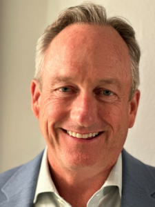
Principal Engineering Geologist, Cotton, Shires and Associates, Inc.
Fault Investigation Challenges and Issues In The Urban Setting of Santa Monica, California — A Reviewer’s Perspective
Abstract: TBD
Bio: Michael Phipps, P.G., C.E.G., is a Principal Engineering Geologist with Cotton, Shires and Associates, Inc. in Thousand Oaks, California. A Southern California native and 1987 graduate of the University of Southern California, Michael has spent the past 39 years gaining diverse technical, project management, operations management and executive experience in the geotechnical industry, predominantly in southern California. His technical expertise includes geotechnical evaluation and remediation of landslides and other geologic hazards, coastal hazard evaluation, fault hazard evaluation, engineering geological site characterization, technical/peer review for government agencies, and is a respected expert consultant/witness on litigation matters. Michael started his career working for former State Geologist and highly respected expert, the late Dr. James E. Slosson. During his 7+ years with Slosson & Associates he received a unique and well-rounded upbringing as an engineering geologist working on a variety of litigation support matters typically involving large landslides or distressed structures, performing peer review for several southern California cities, and observing large hillside mass-grading operations in a second-party role for a large residential developer in Los Angeles, Orange, Riverside, and San Diego counties. For the past two years he has been the lead engineering geological peer reviewer for emergency landslide stabilization measures for the 720-acre Greater Portuguese Bend Landslide Complex in Rancho Palos Verdes.
Over the course of his career, Michael has planned and completed multiple fault surface rupture hazard studies within the Simi-Santa Rosa Fault Zone, as well as studies on the Holser Fault, San Fernando Fault, and Stevenson Ranch zone of deformation. He has also peer reviewed over one hundred fault surface rupture hazard studies for proposed development projects in the cities of Santa Monica, Malibu, Palmdale, Simi Valley, and Moorpark, California. Michael has been a geotechnical peer reviewer for the City of Santa Monica since 2012, but more notably has been the reviewer of all fault studies conducted in the City since January 2018 when the Santa Monica Fault was zoned under the Alquist-Priolo Earthquake Fault Zoning Act.
 Chris Smith and Ehsan Dezhdar
Glotman Simpson
Seismic Modelling + Performance of High-Rise Concrete Shear Wall Building Adjacent to Fault
Abstract: This study focuses on the seismic design and response of a new 37-story residential tower in San Diego, CA that sits directly adjacent to an active fault. Given the adjacent active fault, near-fault effects were extensively evaluated in the development of the ground motions and PBSD approach. GMs were developed with near-fault effects and the non-linear time history analyses (NLTHA) included simultaneous application of vertical and horizontal time series, in addition to, the permanent vertical ground displacements (VGD) associated with the fault rupture (i.e. fling-step). The ground displacement contour was idealized as a “tilting” or permanent rotation of the tower towards the fault. Fling-step studies were performed to assess whether the VGDs associated with the fling should be applied in a static vs. dynamic fashion. Results of these studies, the PBSD evaluation criteria and GMs for this near fault are discussed herein. Incorporating vertical ground motions in NLTHA is rarely done and it presents many challenges, including but no limited to: numerical convergence, additional degrees of freedom, significant processing times, and validation of analytical results is difficult. Ground displacement effects on building structures are sometimes explored in analytical models, but rarely in the context of a NLTHA. Approaches and techniques we developed to support these highly complex analyses are discussed herein, along with our analytical results. A comparison of structural responses with two-component (horizontal GMs) and three-component (horizontal + vertical GMs) is presented. Compared to the two-component GMs, the three-component GMs are shown to have negligible effects on building drift demands and associated structural responses (i.e. rotational demands on coupling beams and outriggers, core wall flexure, and shear demands, etc.). Vertical GMs were shown to have little effect on the core wall axial-strain demands but significant effects were observed on the column axial demands. Compared to the vertical seismic effects estimated from the empirical equations per LATBSDC, NEHRP, TBI, ASCE 7, etc., we found that the vertical GMs were generating vertical seismic axial demands in the columns that were 500% to 1,000% higher than those values. Techniques developed to evaluate the columns for these unprecedented demands are discussed herein, along with the results of that evaluation.
Bios: Chris Smith, a Partner at Glotman•Simpson, is a licensed Civil and Structural Engineer with expertise in code and performance based seismic design of all building types. Chris is known for his skill in managing structural challenges in high-risk regions. He provides third-party plan checks and seismic peer reviews for various entities including the City of Los Angeles, City of San Diego, California State University, and the University of California.
Dr. Ehsan Dezhdar is a Senior Associate at Glotman•Simpson with over 15 years of experience in structural engineering, specializing in reinforced concrete design, seismic risk assessment, and displacement-based seismic design. Drawing on his doctoral research—which focused on nonlinear time history analysis of high-rise concrete shear walls—Ehsan brings deep technical insight to the performance-based design of towers, particularly in high seismic regions like California.
Ehsan plays a key role in advancing innovative seismic solutions within our team, contributing to the design of resilient, code-exceeding buildings. He has presented his work at leading international conferences on earthquake engineering, reinforcing his commitment to bridging research and practice to better inform the built environment.
Nick Oettle, Ph.D., P.E., G.E.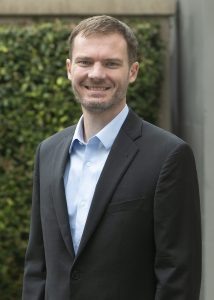
Senior Consultant, GEI Consultants, Inc.
Designing Infrastructure for Surface Fault Rupture
Abstract: Recent earthquakes have provided numerous examples of the effects of earthquake surface fault rupture on structures, including from the 2025 Myanmar Earthquake when the first video ever of surface fault rupture was recorded. Because of the often-unavoidable nature of surface faults, infrastructure must sometimes be constructed near surface faults. This presentation will focus on the latest developments in designing infrastructure for surface fault rupture. Included will be observations from actual surface fault rupture effects on infrastructure, mitigation strategies for designing against surface fault rupture, and numerical modeling analysis techniques that have been recently developed and validated with centrifuge testing. Typical requirements for buildings and dams will be presented, including recommendations from a newly formed working group on incorporating surface fault rupture requirements into the building code.
Bio: Nick Oettle is a Senior Consultant with 18 years of experience in geotechnical earthquake engineering. His project experience includes managing large dam and water infrastructure projects, focusing on earthquake engineering, seismic risk, and numerical modeling. Nick has been involved with the USSD earthquakes committee, the development of ASCE 7-22 and 7-28, traveled to Japan as a member of the GEER reconnaissance team for the 2016 Kumamoto Earthquake, and has authored over 30 technical publications. He earned his Ph.D. in Geotechnical Earthquake Engineering from UC Berkeley developing numerical modeling techniques for surface fault rupture interaction with structures. Recently, he has led a working group to add surface fault rupture provisions to the building code.
7th Kenji Ishihara Colloquium Series on Earthquake Engineering | Day 2
One-Day Short Course
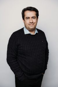
Dr. Rui Chen, California Geological Survey
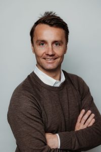
Alexandra Sarmiento, P.E., P.G., CEG | GeoPentech, Inc.; University of California, Los Angeles
Dr. Stephen Thompson, Lettis Consultants International, Inc.
Friday, August 22nd, 2025, 8:30am-3:30pm
University of California, San Diego
Franklin Antonio Hall 1301
The second day of the 7th Kenji Ishihara Colloquium Series on Earthquake Engineering, cohosted with EERI UCSD, will be a workshop focused on advances in Probabilistic Fault Displacement Hazard Analysis (PFDHA), featuring expert-led sessions on recent initiatives, computational tools, and practical applications. Presentations provide attendees with a comprehensive overview of current methods and emerging approaches, complemented by real-world application examples.
Click the image on the right to view the event flyer.
Click here to go to Day 1 of the 7th Kenji Ishihara Colloquium Series.
ABSTRACTS
Fault Displacement Hazard Initiative (FDHI) Program Overview, Scenario-Based FDHA Computational Tools
Alexandra Sarmiento and Yousef Bozorgnia
The Fault Displacement Hazard Initiative (FDHI) Project is a community-based research program that was established to advance the state-of-practice in fault displacement hazard analysis (FDHA). Toward this end, a comprehensive and standardized database of fault displacement measurements, surface rupture maps, and supporting information from 75 historical, surface-rupturing earthquakes was created. Four new fault displacement models (FDMs) providing probability distributions for surface fault displacement were developed using the new database. The results from this first phase of the FDHI Project are published in Earthquake Spectra‘s “Fault Displacement Hazard Analysis Special Collection.” The new models are implemented in a publicly available Python package and Excel workbook.
Probabilistic Fault Displacement Hazard Analysis (PFDHA) – An Overview
Dr. Rui Chen
Fault displacement hazard analysis (FDHA) provides quantitative estimates of surface fault displacement from future earthquakes —critical for the safe design of infrastructure that crosses or lies near active faults. This presentation reviews the fundamentals of FDHA and briefly compares its two primary methodologies: deterministic FDHA and probabilistic FDHA (PFDHA). The focus of this presentation is on PFDHA, which extends the methodology of probabilistic seismic hazard analysis by replacing ground motion models with fault displacement models and incorporating additional probabilistic elements to account for the occurrence of surface rupture (i.e., the earthquake approach). Key components of the PFDHA framework are outlined, and their integration is demonstrated through an open-access Fortran implementation, accompanied by example results. While the presentation centers on principal displacement, distributed displacement is also briefly discussed. The talk further highlights evolving building code requirements, emerging national and international guidance, and ongoing research efforts to advance PFDHA.
Fault Displacement Hazard Analysis Example Applications
Dr. Stephen Thompson
This talk will review key components of fault displacement hazard analysis for the evaluation of design and/or seismic safety of various types of infrastructure, including both lifelines (gas and water pipelines, rail lines) and structures with fixed footprints (dams, buildings). Uncertainty in the location of active faults has been and will continue to be the most vital part of the hazard assessment for most projects. Aside from the mantra of location, location, location, the talk will provide a series of example applications for both principal and distributed displacement hazard that will discuss the implementation of published models for PFDHA, common mistakes or misconceptions we have observed, which model components dominate the uncertainty in hazard, and how logic trees can (and should) incorporate epistemic uncertainties that go beyond the currently available published models. The talk will also provide some suggestions—and hopefully generate some discussion—about how to communicate the results of a PFDHA to aid in decision making.
MEET THE INSTRUCTORS
Dr. Rui Chen
 Rui Chen is a Senior Seismologist with the California Geological Survey (CGS), where she has served since 2008. Her expertise includes ground motion hazard analysis to support CGS’ regulatory liquefaction and earthquake induced landslide hazard mapping program, as well as the review of geotechnical investigations for critical facilities such as hospitals, schools, and nuclear installations. She conducts research on probabilistic fault displacement hazard analysis, including the development of fault displacement and rupture probability models. She also contributes to statewide earthquake shaking potential maps and earthquake loss estimation for California. Rui Chen holds a Ph.D. in Civil and Geological Engineering from the University of Manitoba, Canada, and M.S. and B.S. degrees in earthquake sciences from institutions in China. She is a licensed Professional Engineering Geologist in California and has over three decades of experience in academia, consulting, and applied geosciences.
Alexandra Sarmiento
 Alexandra Sarmiento is a seismic hazard analyst at GeoPentech, Inc. and a researcher at the University of California, Los Angeles (UCLA) with 15 years of experience in consulting practice and academia. Her expertise includes seismic source characterization, ground motion hazard analysis, ground motion development, and fault rupture and displacement hazard analysis. Alexandra is part of the Fault Displacement Hazard Initiative (FDHI) research project at UCLA, where she led the development of a new, high-quality database of mapped surface ruptures and fault displacement measurements. She also led a comprehensive technical comparison of new and existing fault displacement models. Alexandra has B.S. and M.S. degrees in Geological Engineering and Geology, respectively, from the University of Nevada, Reno and is registered in California as a Professional Engineer, Professional Geologist, and Certified Engineering Geologist.
Dr. Stephen Thompson
 Stephen Thompson is a Senior Principal Engineering Geologist at Lettis Consultants International, Inc. (LCI) where he specializes in the characterization of active faults for hazard evaluation. Since completing his PhD in Geological Sciences at the University of Washington in 2001, Steve has been trying to provide clients and colleagues with useful information to help quantify and mitigate the hazards of surface-fault rupture and strong ground shaking. Steve spends much of his time trying not to be overwhelmed by the uncertainties—real and imagined—involved in fault source characterization for seismic hazard analysis (PSHA and DSHA) and fault displacement hazard analysis (PFDHA and DFDHA). Being able to effectively communicate with engineers keeps him up at night.
PROGRAM
Moderator: Taylor M. Gater, P.E. | GeoEngineers, Inc. || EERI San Diego Chapter Director of Events
| Time | Topic & Speaker | |
|---|---|---|
| 7:30am | 8:30am | Registration and Breakfast |
| 8:30am | 8:35am | Welcome and Overview of Program |
| 8:35am | 9:35am | (P)FDHA Overview Dr. Rui Chen | California Geological Survey |
| 9:35am | 9:45am | Break |
| 9:45am | 10:45am | Fault Displacement Hazard Initiative (FDHI) Program Overview Alexandra Sarmiento, P.E., P.G., C.E.G. | GeoPentech, Inc.; University of California, Los Angeles |
| 10:45am | 11:00am | Break |
| 11:00am | 11:45am | Scenario-Based FDHA Computational Tools Alexandra Sarmiento, P.E., P.G., C.E.G. | GeoPentech, Inc.; University of California, Los Angeles |
| 11:45am | 12:45pm | Lunch |
| 12:45pm | 2:15pm | FDHA Example Applications Dr. Stephen Thompson | Lettis Consultants International, Inc. |
| 2:15pm | 2:45pm | Discussion and Colloquium Wrap-Up |
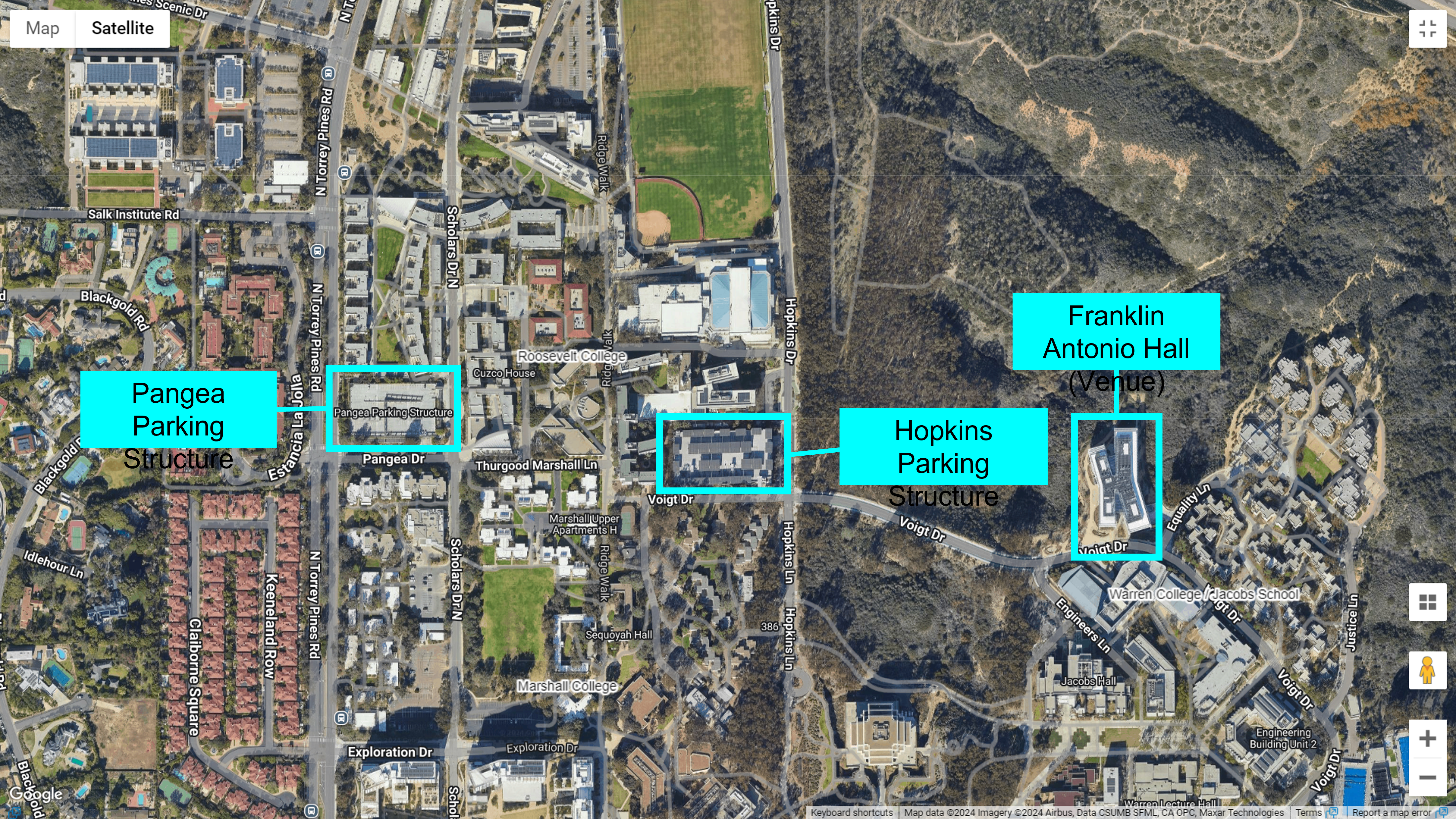
VENUE
University of California, San Diego
Franklin Antonio Hall 1301
3180 Voigt Drive
La Jolla, CA 92093
REGISTRATION
Click here to register for the colloquium. Registration closes on Monday 8/18 at 11:59pm.
LODGING
Click here for a list of hotels near UCSD.
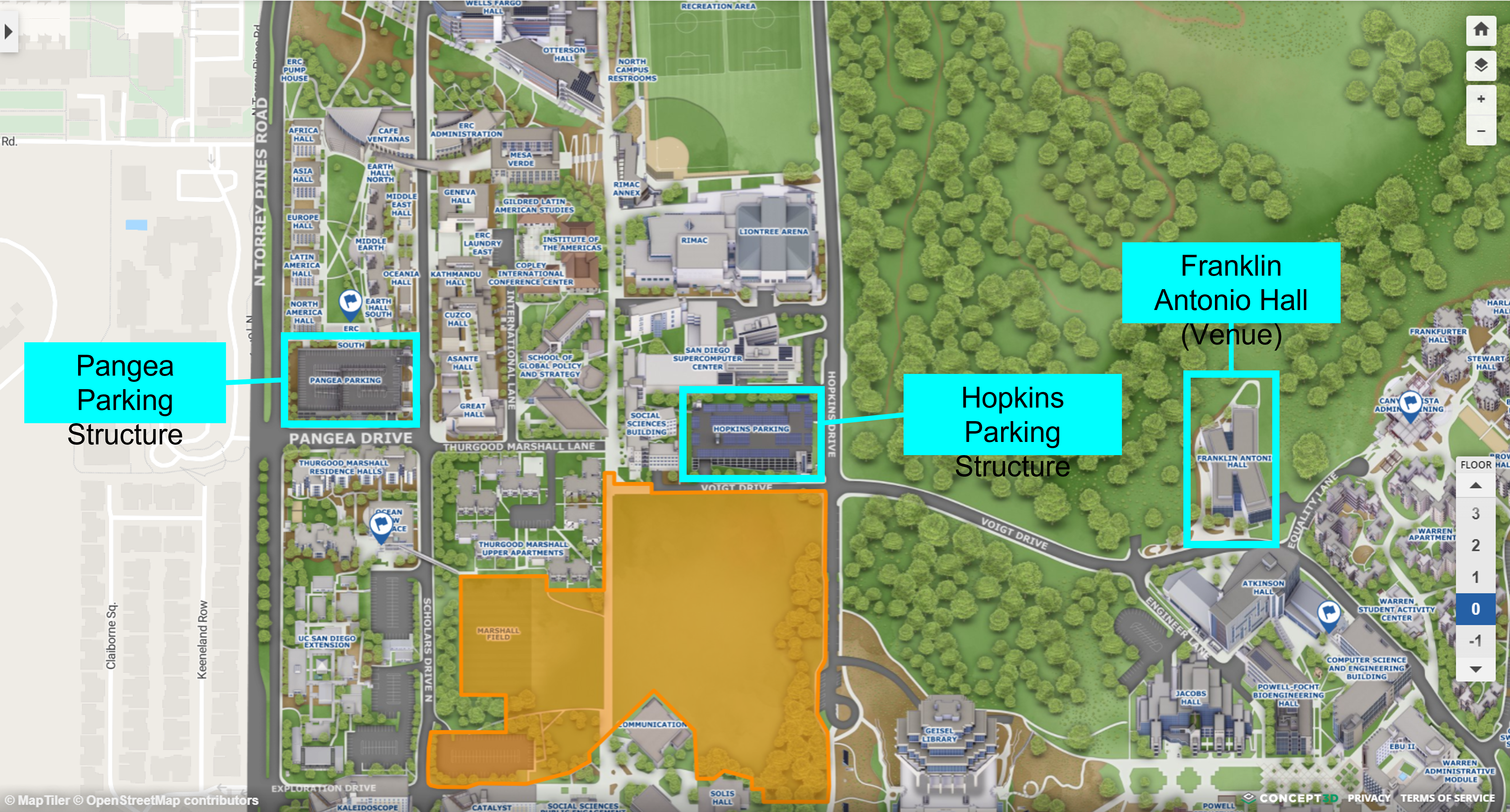
PARKING
For $8 per day, conference parking permits are available in advance through UCSD’s Parking Portal website, which you can access by clicking here. In order to purchase a parking permit, you will need to create an account. When you click on the aforementioned link, it should show a “Guest User Registration” form. Otherwise, click on “SIGNUP” in the upper right corner of the webpage. Once you fill out the form and create an account, follow the prompts to purchase your conference parking permit for the days you will be attending the colloquium.
You can also pay for parking through the ParkMobile app or website the day-of the colloquium. More information can be found here.
There are two structures available for parking near Franklin Antonio Hall: Hopkins and Pangea. The closest parking structure to the venue is Hopkins Parking Structure (view here or here), located on Voigt Dr. off of Hopkins Dr. If Hopkins is full, please go to Pangea Parking Structure (view here or here), located on Pangea Dr. off of N. Torrey Pines Rd. You may only park in B-spaces with your pre-purchased conference parking permit.
Click image below to see the parking structures and venue highlighted (from https://maps.ucsd.edu/map/default.htm):
Click image below to see the parking structures and venue highlighted on Google Maps (from https://act.ucsd.edu/maps/):